Overview
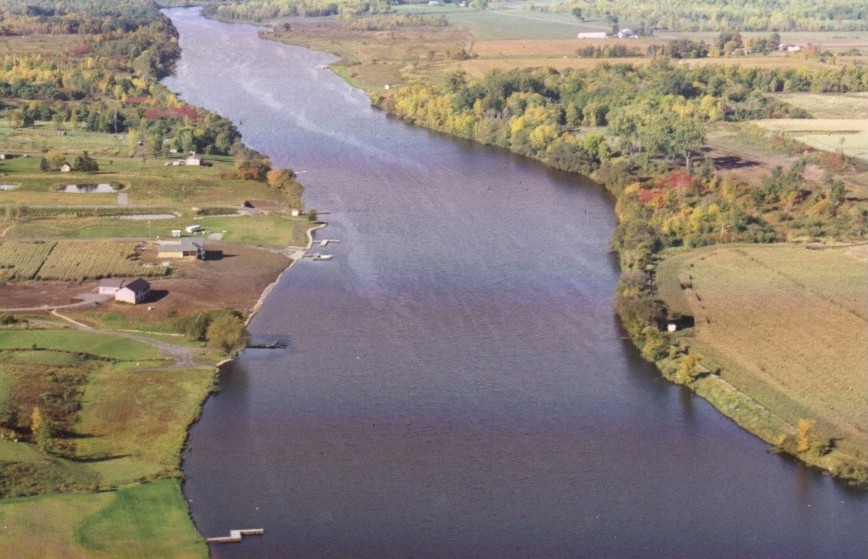
A pilot study of capping techniques was conducted in a section of the lower Grasse River between July and October 2001 to better understand how different capping materials could be installed on the river bottom using various placement techniques. Capping is being evaluated as a possible cleanup alternative that may be considered along with other alternatives for contaminated sediment in the lower Grasse River.
Capping is a technique where clean materials are placed on top of contaminated sediments to isolate the contaminants from the environment. The primary contaminant of concern in the Grasse River sediment is polychlorinated biphenyls (PCBs). PCBs are a group of more than 200 manmade chemical compounds, and were widely used in industry for their insulating and flame retardant properties. These chemicals were primarily used in hydraulic systems and transformers at the Massena Operations. The manufacture and sale of PCBs were banned in the United States in 1979.
The capping pilot study was conducted by Arconic (formerly Alcoa) with oversight from the US Environmental Protection Agency (EPA), US Army Corp of Engineers and the St. Regis Mohawk Tribe.
Project Details
Alcoa Inc. - Massena West Facility
- Capping was performed July 9, 2001 through October 19, 2001.
- Capping was performed over a 750- foot stretch of the lower Grasse River located approximately 1 mile downstream of the Arconic (formerly Alcoa) facility discharge (Outfall 001).
- The different types of capping materials included (alone or in combination):
- 1:1 sand/topsoil mixture;
- granulated bentonite (clay) material; and
- AquaBlok™ material (a solid aggregate covered in clay).
- The different placement techniques included (alone or in combination):
- surface and subsurface placement via mechanical clamshell;
- subsurface placement via tremie pumping; and
- surface placement via pneumatic broadcasting (bentonite only)
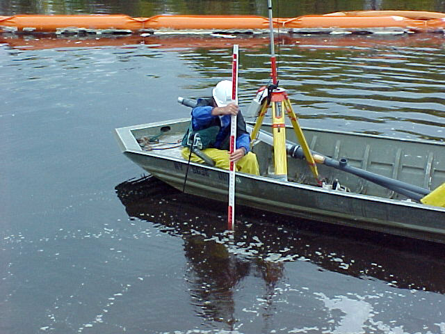
- Placement of cap materials was monitored by using both conventional survey methods and a sophisticated WinOps positioning system that utilizes the Global Positioning System (GPS).
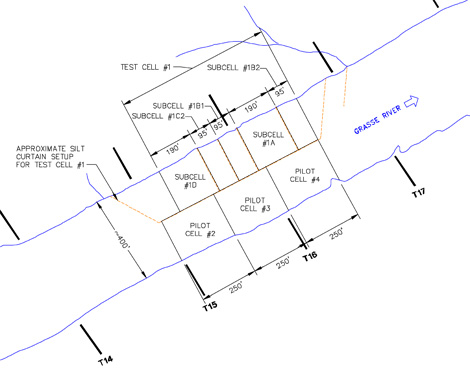
- Capping was performed in two phases: an initial "Test Cell" was used to test the potential cap materials and placement techniques. The real-time results from the Test Cell were evaluated and select capping techniques and cap materials were carried forward in the "Pilot Cells" for testing on a larger scale.
- During capping activities, an in-river silt curtain containment system was used around the perimeter of the cell being capped.
- An extensive monitoring program was conducted prior to, throughout, and after the capping pilot study work. Water quality, cap thickness and PCB concentrations, benthic organisms, and other parameters were monitored.
Summary
Results of the pilot study indicate that a cap to cover the PCB-containing sediments can be successfully constructed in the lower Grasse River. Testing of several application methods and capping materials found that optimal results were achieved with a 1:1 sand/topsoil capping material applied - at the water surface or subsurface - via a clamshell bucket attached to a barge-mounted crane. This combination was capable of generating a cap:
- With good uniformity and thickness;
- With no significant PCB entrainment from the in-place sediments (cap materials remained clean during placement);
- No significant resuspension of in-place sediments; and
- With no significant separation of the sand/topsoil mixture during placement.
The Capping Pilot Study was carried out with little apparent short-term impacts on the environment. Water quality impacts during capping were negligible. Nearshore aquatic vegetation areas were left undisturbed, and on-shore land disturbance (for the staging area) was minimal since a prior staging area was utilized. Monitoring of the cap area was also conducted in 2002 and 2003 to collect additional information related to the physical, chemical and biological conditions in the cap following placement. The 2002 data indicated that the cap remained in tact and was functioning as designed. A summary of these monitoring results can be found in Public Presentations. The 2003 data indicated that the cap and some of the underlying sediments were disturbed by what was later determined to be an ice jam related scour event. A series of investigations were conducted to evaluate the impact of the ice jam on the sediments, water column, and fish of the lower Grasse River and to evaluate possible options for preventing future ice jam related events. The results of these investigations are provided in the document titled Addendum to the Comprehensive Characterization of the Lower Grasse River which is currently being finalized. An overview of ice management options under evaluation can be found at Ice Management Evaluation.
Back to top
Photos
Capping was performed in two phases: an initial "Test Cell" was used to test the potential cap materials and placement techniques. The real-time results from the Test Cell were evaluated and select capping techniques and cap materials were carried forward in the "Pilot Cells" for testing on a larger scale. These Test and Pilot Cells are identified on the map below.
View photos from General Construction Activities, Capping Activities in Test Subcells and Pilot Cells, and Monitoring Activities.
Back to top