Overview
The Remedial Options Pilot Study (ROPS) was performed between April and December 2005 to provide information pertaining to potential remedial alternatives for addressing contaminated sediments in the lower Grasse River. The ROPS was conducted by Arconic (formerly Alcoa) with oversight from the United States Environmental Protection Agency (EPA; lead), New York State Department of Environmental Conservation (NYSDEC), and the St. Regis Mohawk Tribe (SRMT). This group has been working together to develop a comprehensive clean up approach to address the sediments in this area of the river that are impacted by polychlorinated biphenyls, or PCBs, and the ROPS is part of this collaborative process. ROPS construction activities consisted of a combination of removal and capping activities, including:
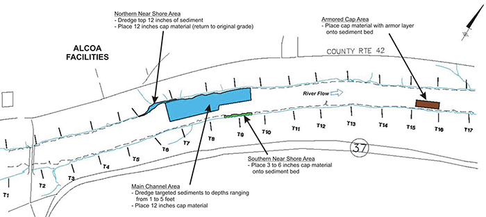
- Sediment removal by dredging and capping in the main channel and adjacent northern side slope area;
- Sediment removal and capping in the northern near shore area;
- Thin-layer capping in the southern near shore area; and
- Armored capping in the main channel. The targeted location of each component of the project is shown on the figure below.
Project Details
Historical Overview
The primary contaminant of concern in the Grasse River Study Area is PCBs, and a critical goal of both the Remedial Options Pilot Study and future remedial actions is to reduce potential risks associated with elevated levels of PCBs in fish. To achieve this goal, Arconic (formerly Alcoa) has been sampling Grasse River sediments, surface water, and biota since the early 1990s. Using these data, the company began evaluating potential remedial alternatives to address PCBs in river sediments, surface water, and fish and other biota by performing two pilot studies. In 1995, sediments were dredged from a 1-acre area of the river directly offshore from the main wastewater discharge outfall from the Massena West Plant as part of a Non-Time-Critical Removal Action (NTCRA). In 2001, a Capping Pilot Study was performed in a 7-acre area of the river to evaluate subaqueous (under water) capping. The information gathered during prior investigations and the pilot studies were used to develop an Analysis of Alternatives (AA) Report for the site that was submitted to EPA in June 2002.
Pilot Study Locations
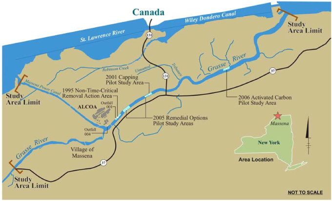
Data collected in 2001 and 2002 indicated that the subaqueous cap placed during the 2001 Capping Pilot Study was intact, there was no evidence of PCBs moving into or through the cap, and a variety of organisms were re-colonizing the capped area. However, monitoring of the river in the spring of 2003 revealed that the cap, and in some areas the underlying sediment, had been disturbed. A severe ice jam that occurred in the lower Grasse River in the spring of 2003 caused the scouring of sediments in some portions of the study area. The ice jam-related scour was not expected, and the pilot cap had not been designed to withstand the forces generated by the severe ice jam event.
Overview and Results
The 2003 ice jam revealed that, despite the extensive studies undertaken to date, several outstanding technical issues needed to be studied prior to developing a comprehensive, effective remedy for the site. To gather some of the information to address these issues, EPA and Alcoa agreed to perform the Remedial Options Pilot Study during the 2005 construction season (May through November). The elements of the study were as follows:
- Dredging in the main channel of the river (including the side slopes) and in the northern near shore area;
- Placing various types of sediment caps (1-foot thick, thin layer, and armored) in different locations in the study area;
- Monitoring conditions in the river before, during, and after dredging and capping activities.
- Conducting profiling surveys to characterize the topography of the river bottom and the depth of sediments removed from the study area. These surveys were done before dredging to establish a baseline, during dredging to assess progress, and after dredging and capping activities to evaluate the effectiveness of the efforts. In general, the results during and after dredging indicated that, in the main channel, significant amounts of targeted sediment remained, and the irregular nature of the river bottom with boulders and rock outcrops in some areas limited the ability to remove all of the targeted sediments.
- Collecting more than 800 water samples for PCB and solids analyses. While there were no problems with concentrations of solids during the project, PCB action levels were exceeded on 8 days. When these exceedances were experienced, additional samples were collected near the dredge area to better understand the situation, and changes in operations (such as slowing the debris removal operations, altering removal methods, and limiting times of operations) were implemented to address the issue.
- Collecting more than 85 air samples for analysis of PCBs, particulate matter, and other compounds. There were no exceedances of the action levels for PCBs or other compounds. Some elevated levels of particulate matter were measured, but further assessment revealed the exceedances were not related to the project.
- Collecting 144 fish samples for PCB analysis. PCB levels in fish tissue were significantly elevated relative to those measured in smallmouth bass, brown bullhead, and spottail shiner in 2004 prior to conducting the ROPS. Future monitoring efforts will be necessary to put these results in perspective and address the question of whether these increases are temporary and if the previously observed downward trend in PCB concentrations will be re-established. Data collected in 2006, one year after completion of the ROPS, indicated these increases were temporary. PCB levels measured in these fish in 2006 were similar to those observed prior to the ROPS.
- Monitoring was also carried out to gauge impacts associated with odor, noise, and lighting. No issues associated with the project were identified. Longer-term post-construction monitoring efforts were conducted in 2006 and 2007 to assess the performance and stability of the caps. A summary presentation of ROPS activities and monitoring results was given at a community meeting in March 2006. Monitoring results from 2006 and 2007 will be made publicly available once approved by EPA.
Installation of an ice control structure (ICS) was also included in the original ROPS program to serve as an interim and potentially longer term measure to prevent future ice jams from occurring. However this was not pursued due to community concerns related to the proposed location of the structure which was several miles upstream of the project study area. An evaluation of long term structural ice control options is continuing in support of the development of the revised AA Report for the Grasse River.
Dredging
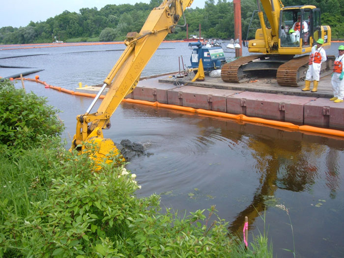
Dredging efforts in the main channel of the river were designed to remove PCB-containing sediments, assess the implementability of dredging in the river, and evaluate the effectiveness of removal efforts. Dredging began in June and targeted the removal of up to 6 feet of river sediment. By mid-September, far less sediment had been removed than originally anticipated due to a variety of issues that complicated removal of the remaining materials.

Hydraulic Dredging in the Main Channel Area
The river bottom was irregular and uneven, and dredge operators frequently encountered hard bottom, rocks, or debris near the bottom of the targeted removal depth, which is where the most elevated PCBs levels were located due to burial over time by cleaner sediments. The rocks and debris also resulted in equipment damage in some areas. These problems were compounded by the fact that as sediment removal becomes more difficult, typically more water is dredged with the sediments, and that excess water has to be separated from the sediments. Collectively, all these issues significantly reduced dredging productivity. Alternative dredging equipment and approaches were implemented to address the removal problems, and geotubes (which are large sock like tubes made of fabric) were brought in to help manage the additional water encountered during dredged sediment processing. Although these adjustments resulted in incremental improvements in some areas, the lower productivity rates and other difficulties limited what could be accomplished within the single construction season planned for the study. As a result, only about 40% of the targeted sediments were removed from the main channel, and surface sediment PCB concentrations were significantly higher after dredging than they were before dredging.
Removal was also carried out in a northern near shore area, as there are unique implementation considerations associated with removal in these shallow areas where water is typically less than 5 feet deep. PCB concentrations in this area were also much lower than those encountered in the main channel dredging. Removal in the targeted northern near shore was successful, although much more material was removed than originally anticipated. With the exception of survey control issues, no significant operational issues were encountered in the northern near shore area.

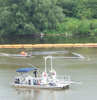
Large Rocks and Debris Removed from the River
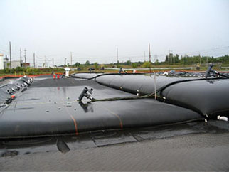
Geotubes Used for Dewatering
Capping
After dredging in the main channel, the removal areas were covered, or capped, with approximately a 1 foot thick mixture of sand and topsoil to limit the potential for exposure to remaining PCB-impacted sediments. In the northern near shore area, the same sand and topsoil mixture was placed to return the area back to its original (pre-removal) elevation.
Mechanical Removal in the Northern Near Shore Area
Placing Capping Materials
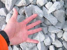
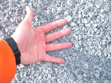
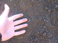
Capping Materials: Armor Stone, Gravel, and Sand/Topsoil
Caps were also placed in two areas that were not dredged. A thin layer cap, consisting of 3 to 6 inches of sand and topsoil was placed in the southern near shore area over top of the existing sediments. In addition, an armored cap was placed in the main channel in an approximately 1-acre location downstream of the dredging areas.
The armored cap, which was designed specifically to resist the faster water flows and scour associated with ice jams, consisted of a bottom layer of sand and topsoil, a middle filter layer of coarser material, and then a top layer of large stones. The various caps will be monitored to determine the effectiveness of the different approaches, and to assess if the armor stones provide additional permanence or protection from ice-related scour. An underwater video obtained of the armored cap area shows the armor stone with finer-grained material on top or in between the armor stone.
Monitoring

Collecting Samples for the Monitoring Program
Sediment Core Collection
A variety of monitoring efforts were conducted to support the study. A summary presentation of ROPS activities and monitoring results was given at a community meeting in March 2006. These included:
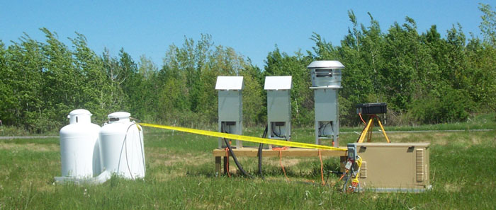
Air Montoring Equipment
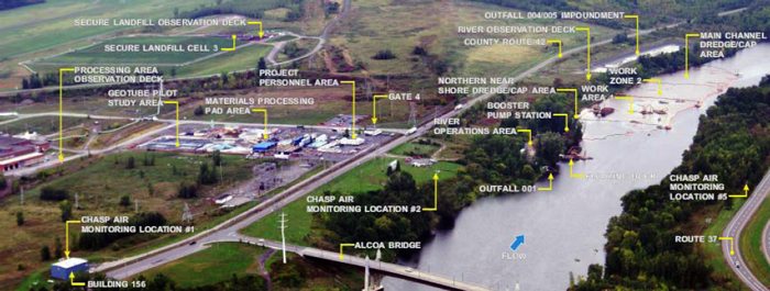
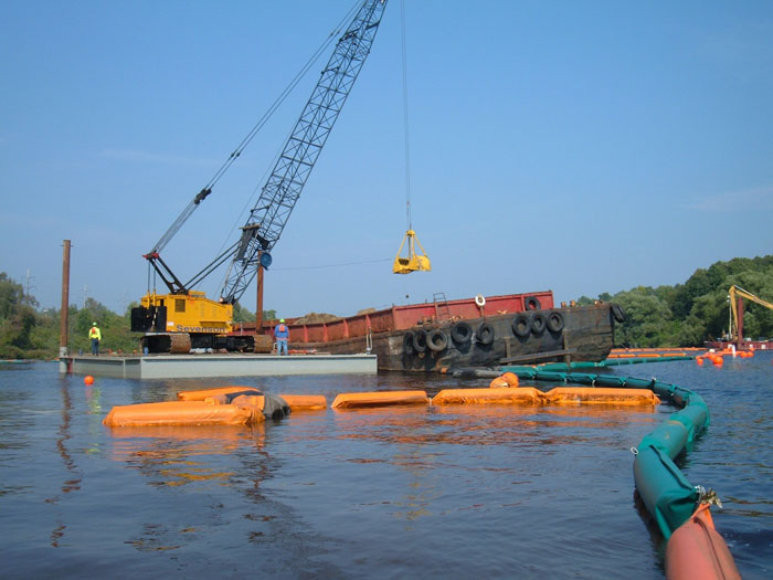
Aerial View of ROPS
Photos
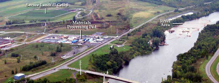
Materials Processing Pad | River Area | Secure Landfill Cell 3
Back to top